
The National Hurricane Center noted a 20% chance of tropical development for a “broad area of low pressure [that] could form in the Central or Western Gulf of Mexico.” Sure as dogs sniff each other’s butts, a cursory Google search popped up all sorts of stories regarding the potential system. Rather than discussing the low ethics scare media and alarmist click bait Facebook/Webpages, this post is going to illustrate why the potential system is likely no threat.
Looking at the last 10 model runs the model output varies wildly.
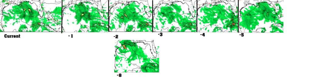
The image above, compiled from Tropical Tidbits, is the most recent 5 GFS model runs on the top row, and the run that shows the most impact to Houston on the bottom. A few things stand out. All the model runs show a tropical disturbance. Some of the runs imply a circulation with no corresponding low pressure at the surface. Some show a closed circulation at the surface. The worst of the bunch for Houston shows a tiny low end tropical storm south of Sabine Pass.
From this we can safely conclude at a minimum a tropical disturbance will be in the Gulf of Mexico early next week. It’s also a safe statement to say somewhere on the Texas coast will have rain and some wind impacts from the system.
Beyond those two statements it gets more dicey. The high pressure system that has plagued us this summer is still with us. It has meandered a slight bit north, and the disturbance is riding along the southern periphery of the ridge. Looking at the ridge for the same time periods it holds strong for the most part. This means the disturbance will generally move westward. Most of the model runs do suggest a slight deviation from due west by the time the system would be nearing Texas, so if a system were to form it possibly could gain a little latitude.
So what does all this mean for us?
This is all about a broad area of low pressure that could form in the Gulf early next week. That means we have to wait and see both if a low forms, and if so where it forms. An area of low pressure is likely to form, so the where is the more important aspect. Once the low forms the system will generally move westward, but as it nears Texas start to move a touch north of west.
If the low forms in the southern regions where the models are indicating the impact on Southeast Texas is not much. If it forms in the more northern areas we could see some rain and afternoon/evening thunderstorms along with some gusty winds. As it looks now, the worst case would be a weak tropical storm.
I say all this with a HUGE caveat. The Gulf is absurdly hot right now, with some places having a water temperature essentially 90 degrees. Thanks to the high pressure system that’s been plaguing us this summer the northern Gulf is warmer than the Bay of Campeche. Go figure. The northwest Gulf of Mexico already has a history of having storms spin up unexpectedly quickly.
Humberto in 2007 was the fastest storm intensification on record in the Atlantic Basin. In 2017 Imelda rapidly spun up just offshore. They both intensified quickly and dropped copious amounts of rainfall, seemingly out of the blue given their rapid development. With the high water temperature, low shear, and broadly divergent upper level winds another rapid intensification occurrence can’t be excluded.