
Today is June 19, and we have our second named tropical storm of the season in the Atlantic. The National Hurricane Center also notes an area to the east-southeast of the new tropical storm has a 50% chance of development. This is a good time to explain how El Nino impacts hurricane season for Southeast Texas, and why we don’t have to worry about systems far out in the Atlantic.
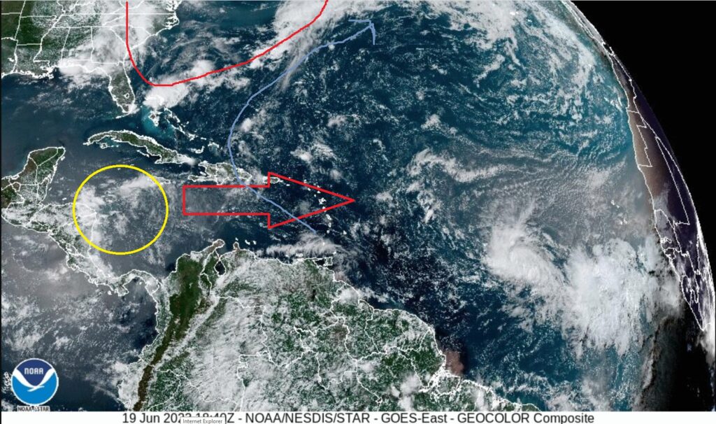
This is a current satellite image of the tropical Atlantic. During El Nino a trough of low pressure often sets up off the east coast. Additionally, winds in the upper levels of the atmosphere blow from a westerly direction, usually over the Caribbean and central Atlantic, though close to the equator the winds are less likely to be westerly. Both of these features are marked in red.
What effect does this have? Winds form the west in the upper levels prevent tropical development and cause hurricanes to die. If a system does form outside of the band of westerly winds the trough of low pressure causes the storms to recurve out to sea before making it to the Gulf. This is marked in blue.
With that in mind, what still poses a threat to enter the Gulf and potentially threaten Southeast Texas? The first is something simply forms in the Gulf. A second threat is if something from the Atlantic passes through the westerly winds and makes it to the area circled in yellow. The yellow is the approximate region where the system has moved too far west to be recurved out to see by the trough. A more rare occurrence, but one that happens every hurricane season is a tropical wave forms over South America and emerges into the Caribbean rather than Pacific Ocean. This type of wave would likely be beyond the area where the trough could influence the system’s movement.