
Here’s the TLDR version, and a detailed version follows:
TL;DR Version
Right now, it’s too soon to have any definitive idea of what’s going to happen with Beryl. Yes, it’s a powerful and concerning storm at the moment. By tomorrow night? It may be less so, though the extent of this weakening is a key question. Rather than pretend to know the future, this post outlines what to look for in order to forecast Beryl’s path.
Big Picture
- Stronger Storm, More Northerly Track: Stronger storms will track more northward. Beryl’s current track is slightly north of a running compilation of the National Hurricane Center’s (NHC) 12-hour forecast, suggesting a southward bias in the models.
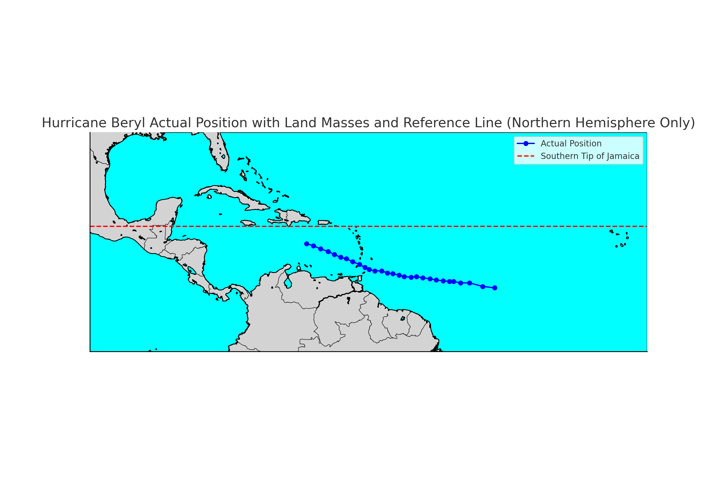
- Impact of Jamaica: The dashed line on the map below represents the southern tip of Jamaica. Beryl is on a trajectory to cross this line, which could significantly impact the storm’s state post-Jamaica.
Factors to Watch
- Strength and Track Post-Jamaica: The system’s strength and position after crossing Jamaica will shape its future path. A stronger system will feel more influence from an upper-level low and move northwesterly, while a weaker system will move more westerly.
- Yucatan Peninsula Crossing: The storm’s crossing point over the Yucatan Peninsula will affect how much latitude it gains in the Gulf of Mexico.
- High-Pressure System: The evolution of the high-pressure system currently causing our heatwave will determine the system’s path. As it moves east, it could allow a stronger Beryl to gain latitude and potentially recurve northward.
Detailed Version
Right now, it’s too soon to have any idea what’s going to happen with Beryl. Yes, it’s a powerful storm now. By tomorrow night? Not so much, though the extent of this weakening is a key question. Rather than pretend I know what’s going to happen – since right now no one does – this post shows what to look for in order to forecast the future path for Beryl.
Strength and Track
On a big picture level, the stronger the storm, the more northerly it will track. The image below shows the track history of the system, and if you were to plot that against the National Hurricane Center’s 12-hour forecast, it would show that the track is slightly north of the forecasted track. This suggests that the models have had a bit of a southward bias.
Impact of Jamaica
The dashed line is the southern tip of Jamaica, and the system is on a trajectory to cross the line. Unfortunately, the crossing appears to be situated right as the system reaches Jamaica. The National Hurricane Center has responded to the development by slowly shifting their forecast track northward with new advisories, as seen below.
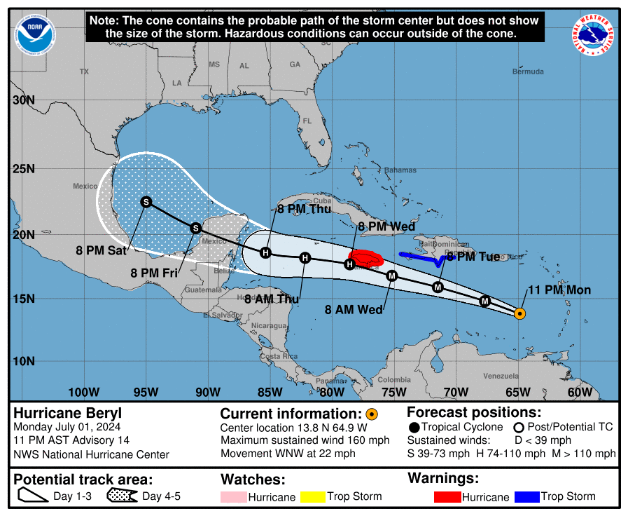
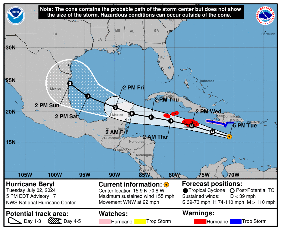
Forecast Track and System Strength
The forecast track has also been a bit slow, reinforcing the idea that the system is more robust than the models understand. A stronger system will feel more influence from the high-pressure area steering it.
This is important because where and how the system passes over Jamaica, and how long it takes, will significantly impact its state after crossing the island. Once that occurs, we can better understand how the forecast track will evolve.
TUTT Cell and Wind Shear
Once the system passes over (or close to) Jamaica, the forecast begins to take shape. Right now, a TUTT cell is ahead of the system, helping it gain a little latitude. The hurricane’s outflow will split the cell into two parts. Beryl is weakening now and will continue to do so as it passes over/near Jamaica, but once it enters the northwest Caribbean, the wind shear will lessen, giving the system an opportunity to restrengthen to some degree.
Future Track Determinants
This brings us to the crucial point. The strength of the system after passing Jamaica, and its potential restrengthening, will determine its future track. The TUTT, split into two segments, will have an upper-level closed low to the southwest of the hurricane. A stronger system will feel more impact from the low and move in a more northwesterly direction, while a weaker system will move more westerly.
Yucatan Peninsula Crossing
The difference between these paths is where Beryl crosses the Yucatan Peninsula and how long it stays over land. If the Yucatan passage is more southerly due to westward movement, the system will struggle to gain latitude in the Gulf of Mexico. Conversely, a more northerly passage will minimize the time over land, allowing a stronger system to enter the Gulf.
High-Pressure System
The third factor to watch is the evolution of a break in the high-pressure system currently causing our heatwave. If the high were to stay in place, it would drive a strong storm into Mexico. However, the high is expected to move, bringing us some relief from the heat but also allowing a stronger Beryl to gain latitude in the Gulf. Depending on how far east the high moves, there is a possibility the storm could recurve northward over open water – a potentially unfortunate outcome.
It’s too early to know how this will evolve. However, we do know what the moving parts are, and this is where and what to look for. Thanks for reading, and I will post again as things develop.